From Chicken to Whitehorse
June, 2002
 |
Here it is, November 1st, and I'm finally writing our
last webpage about Alaska. We made two 800 mile loops around the
state and finally we are headed south.
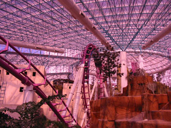
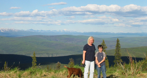
No one was able to identify the "Mystery Location" from
our last page. So here's a new challenge. Not much of a clue
by the picture alone and I bet the web won't help, but if you've been here
you should recognize this place. (One hint -- it's not in Alaska.)
Be the first to send us an e-mail
identifying
this place and win a small prize. |
Below, is the Chicken Creek Saloon in beautiful downtown
Chicken, Alaska, population 25, (give or take a few.) Chicken is about
250 miles northeast of Fairbanks on a dusty, bumpy road they call a highway.
Other than one more building, a gift shop to the left, you're looking at
the entire downtown corridor.
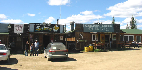 |
It's also the uptown and suburbs but there are two or
three other buildings on the outskirts of town 500 yards down. The
cafe has great home-made pies and guess what's hanging in the saloon? |
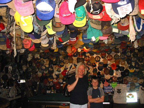
Caps, lots of caps. I received several e-mail guesses.
Here's a couple of them:
. . . .Big Timber (or Big T) bar out in
Kasilof, AK. . . . .
. . . .If not Toad River Cafe then it must be TUSTUMENA LODGE.
. . . . John and Suzie Cook of the Tustumena Lodge. . . . For 11 years,
they've been collecting hats. . . . .Guinness Book of World Records required
that an independent auditor count each and every one of the hats. When
the official number was tallied, there were 20,422 hats in the collection.
But since that count, more hats have piled in. Cook said there are 22,014. |
 |
Sorry to all, but this one went unsolved. It was the
Chicken Creek Saloon in Chicken, Alaska. Several readers sent us
a copy of the article that was in the Peninsula Clarion about the Tustumena
Lodge. I found it interesting that this is the same paper we had
our
picture in, and a story about how we help a school bus that was stuck
in the ice.
Why do they call this place "Chicken?" Well, back
many years ago when they were searching for gold, the miners wanted to
name their little community "Ptarmigan", (which is the name of the Alaska
State bird,) but nobody knew how to spell it. They settled for "Chicken"
instead -- no joke -- it's a true story.
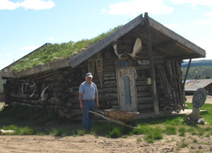 |
We've been thinking about buying a fixer-upper as a learning
project for the boys. I think we found one. It's located on
the "Top-of-the-World Highway" between Chicken and the Canadian border.
It's actually a museum from the gold rush days.
Though this one is a museum, these old, sod roofed buildings
are quite a common sight in Alaska. |
You can see from the next picture why this is called the
"Top-of-the-World highway. The highway is built on the top of a mountain
ridge.
 |
The spring thaw, spring run off, mud slides and falling
trees all create problems for the roads in Alaska, but not this highway.
It's on the top. All of the water, trees, mud and floods are below
the highway. Plus, this road is really close to the Arctic Circle,
i.e. top of the world. |
How would you like to breakdown out here? We came across
an elderly couple in an older motorhome with a fuel pump problem.
After spending an hour trying to help, we told them we would call a tow
truck when we got to the next town, which was about 60 miles ahead.
(Needless to say, there aren't any cell phone towers out here.)
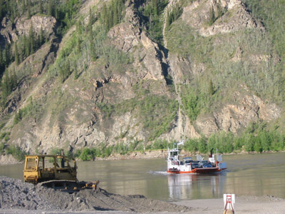 |
We finally arrived at the Yukon River and the outskirts
of the city of Dawson. No bridge here -- to get into town you have
to cross by ferry. This small ferry crosses the river to Dawson,
destination site of the Klondike Gold Rush. It holds about 10 cars
or two motor homes, or one fuel tanker. If you get behind a motorhome
caravan it can be an hour or two wait to cross. |
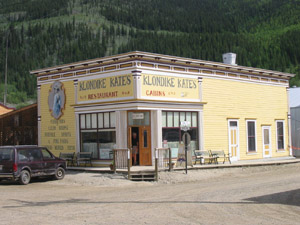 |
Dawson City, in the Yukon of Canada, is like walking
back in time 100 years. Thousands of young men risked life and limb
to reach this place in search of their fortune in gold.
Here's a picture of Klondike Kates, a famous watering
hole.
Dawson is about 10 square blocks of mostly original and
restored buildings from the gold rush days. All of the roads are
dirt except the main road through town. |
So what happened to the people with the bad fuel pump?
Well, I called their roadside service company. I had already learned
that there was only one tow truck in the area large enough to tow a motorhome.
It was at a service station 20 miles farther down the road. There
was also only one place in town that could service the motorhome.
I told the fellow on the phone about this single tow truck. After
I filled him in on the situation he asked,
"What is the number of the highway they are on?"
"Number?", I said. "I don't think it has a number.
It's called the Top-of-the-World Highway."
""Oooo Kaaaay" "Which way are they going", he asked?
"They are heading toward Chicken, ah, that's in Alaska.
But the nearest tow truck and service station is in Dawson back in Canada",
I replied.
He said, "I mean are they in the southbound, northbound,
eastbound or westbound lanes?"
At this point I felt like this guy didn't hear a word
I had been saying, or maybe it was the term 'highway' that had him confused,
so I said "Ah, this is a dirt road that runs 200 miles between Tok,
Alaska and Dawson City, Yukon."
He replied, "Yukon? Is that in Oregon?"
Then he asked, "are they safely off to the side of the
highway out of the flow of traffic?"
My next question to him was, "where are you?"
After I finally got off the phone with this guy, (who
was located in Southern California,) we went to the local RV park and checked
in. It was now an hour later and I thought I'd call the only tow
truck in the area to see if they'd been dispatched to help the stranded
couple. They had not heard a thing. I left them the information
and hoped for the best.
The next morning I called the roadside service company
back. The woman that answered the phone checked the computer and
told me they had dispatched a tow truck. She said that the computer
log showed they first called the nearest large tow truck company in the
U.S. It was located in Fairbanks Alaska, 300 miles away. She
had a note that said they refused to drive that far. She went on
to say that they had a hard time finding a tow company and finally had
to call the one I suggested the night before. Her log showed that
they finally called them five hours later.
I stopped by the service garage and was relieved to see
the elderly couple and their broken motorhome in the parking lot.
The couple told me the that the tow truck showed up at 12:30 a.m.
It turned out that the problem was a pressure sensor that shuts off the
pump if the engine is not running.
I think I know what the confusion was. We have met
a few people that don't really know where Alaska is located. Think
about it. Where is Alaska on most maps of the U.S.? It's an
island off the coast of Southern California next to Hawaii or something.
You may think I'm kidding, but the sad part is -- I'm not.
 |
Dawson has an interesting history. It was built
because of it's location on the Yukon River next to the Klondike gold fields.
Many people think that the Klondike Gold Rush happened
in Alaska. Though most of the gold seekers travelled through Alaska to
get to the gold fields, the rich deposits are actually located in the Yukon
territory of Canada.
|
Just getting to Dawson 100 years ago was an incredibly difficult,
dangerous journey. Of course, gold was the catalyst. Men could
travel one of three routes -- the one that only the most wealthy could
afford was by boat from Seattle along the coast of British Columbia and
western Alaska and up the Yukon River to Dawson. Another route was
over land through Edmonton, Canada -- a route that few people attempted
or survived. The third and most popular route, (because it was the
cheapest,) was by boat from Seattle to Skagway, Alaska.
It would take me several pages to share all of the interesting
stories we heard, so here's just one.
After reaching Skagway by boat, men trekked into Canada
over the Chilkoot Trail or the White Pass. Alarmed at how ill-prepared
most gold seekers were, the Canadian Mounties required anyone entering
Canada to carry one years worth of provisions with them. This translated
into one ton of food, clothing, tools, bedding, etc. per person.
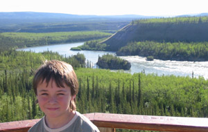
Men would have to carry huge packs on their back and go up and down the
trail over and over again. There are famous photos of the solid line
of men struggling up this very steep trail. After finally getting
their ton of provisions to the top, the men then had to build a boat or
raft to navigate over 300 miles down the Yukon River to Dawson. The
photo above is of Max on the Yukon River at Three Fingers between Whitehorse
and Dawson. This notoriously dangerous spot is where the river is
forced between fingers of rock, creating fast flowing rapids that tend
to hurl boats and rafts onto the rocky edges. Many gold seekers met
their doom at this place.
When the exhausted gold seekers reached Dawson, they found
that gold claims had already been staked by the original discoverers and
miners that were in the area when the discovery was made -- a whole year
before they started their journey to the Klondike !!
Many men ended up going home. Some worked for the
larger mining operations. Though it seems like a heartbreaking endeavour,
almost everything we read about the men (and some women) had a positive
spin. These were young men and women out for adventure -- and they
got it! Interviews with old-timers claim that this was the trip of
a lifetime -- something they would have done again even if they didn't
find their fortune. If you're interested in the Klondike Gold Rush
there's an excellent documentary film that was made in the 1950's called
"City of Gold".
Much of the money that was made was in the service industries.
Through clever marketing and media hype, Seattle grew as thousands of men
came to buy the required provisions. In Skagway, Whitehorse and Dawson,
the stores, saloons, dance halls, stables, and other entrepreneurial ventures
is where most of the money was made. Most of the men simply worked
for a wage and spent their money for supplies and entertainment.
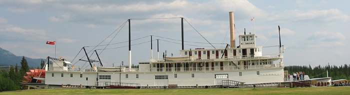
The Steam Powered Sternwheeler "Klondike"
Ships like this were used to transport men, supplies and
gold up and down the Yukon River. Before travelling, I had heard
many a story from my neighbour who, as a teenager, worked on ships just
like this one on the Yukon River.
These boats have a draft of 1 1/2 to 3 feet which makes
them ideal for the wide shallow rivers of Alaska. The Klondike Sternwheeler,
now a museum, sits along the banks of the Yukon in Whitehorse, Yukon.
Ah, yah, that's in Oregon, right?
Darn! I thought this would be my last Alaska page,
but I still have thirteen photos and it's getting too long. So until
next time, (which will be soon,) good luck on the Mystery Challenge.
ã
copyright Nodland 1999-2020